This weekend is the River Severn SSSI and Ramsar Site Walk.
The River Severn Estuary is designated as a Site of Special Scientific Interest as well as being a Ramsar Site, an internationally important and protected wetland area.
Development near a site that has such designations involves a lot of prior planning and developers need to be able to prove that they have mitigated the effect of development on the area.
In the Local Plan Stroud District Council and the developers say they will be consulting Natural England on minimising the effects of this monstrous and constant building site.
However, given that there are protections in place to protect not just the wild birds which feed here – and can be so easily disturbed – but also their food chain and habitats, I’m just not very sure how realistic these promises can be.
A huge amount of issues get thrown up when developing an area like this. The effects of the building site, light, pollution, noise and more people are all things that will be heavy and ongoing. But longer term there are issues of providing a whole new sewerage system to deal with the 5,000+ new houses.
Domestic cats are a real issue for wild birds and having a development so close to the sites where waders and other protected birds feed and roost, and some even ground nest, could have a severe impact on their survival here.
I will be writing more in a post about our special river in a post linking to this walk on the website, but for now here’s the walk. I do hope you enjoy it!
Map of the Severn SSSI & Ramsar Site Walk
The directions and accompanying photos below begin in Berkeley. If you are starting from Sharpness picnic site, join the walk at direction 9 below.
The whole walk takes about 2.5 hours to walk. This is a very flat walk and shorter stretches can be easily done, eg. walking the Severn Way from either Berkeley or Sharpness to the mouth of Berkeley Pill.
1. The walk begins nearly opposite the gatehouse entrance to Berkeley Castle on High Street Berkeley. With the castle on your left walk down the road towards the painted iron bridge and get your first look at The Pill, the river that once was a passage for ships to sail all the way up to the Castle (hence the name of The Mariner’s Arms pub).
2. Turn down Jumpers Lane on your right hand side.
Interestingly this lane was originally called “Junipers Lane” and appears as such on old maps held by the Berkeley Estate, so called for the plethora of juniper trees growing down this lane long ago. The name of the lane got accidentally changed when an official copying from an old map mistook the “n” and “i” in Juniper for a “m” and hence it was forevermore known as Jumpers Lane.
3. Follow Jumpers Lane along with Berkeley Pill on your left, skirting Berkeley on your right. Keep going until the paved road become a footpath at Stock Lane and bear around to the left to keep following the Pill on your left and the narrow footpath.
4. You will come to a bridge, cross and continue on following the river. Soon you’ll come to two gates close together, go through both.
5. At the second gate you’ll see Berkeley power station out on the banks of the Severn in front of you
6a. Keep walking through the final field and over the stile when you will hit Oakhunger Lane.
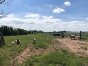
6b. Cross straight over here and you’ll see the Severn Way footpath sign taking you down along the river. Keep walking down the footpath until it opens up into a sheep filled field and continue walking with the The Pill on your left.
7. Following the meanderings of the Pill and after around 15 minutes walk you’ll see where the Pill meets the River Severn on its passage to the sea. From here turn right up towards Sharpness with the wind turbine, docks and pier in the distance.
The habitat here is incredibly important for a wide range of species, hence it being deemed so scientifically significant. At low tide you can see the mud flats and sand banks which provide such rich feeding grounds for so many wading birds. A lot more information on the significance and ecology of this area will accompany this walk on the website.
8. At the end of the riverside footpath go through the gate posts.
9. Here you can go left to the picnic area and have a rest and admire the piers. Or bear right through the gate posts and walk with the houses of Severn Road on your left and up towards the roundabout at the end of the bypass with the docks on your left hand side.
10. At the roundabout be careful on this busy road as lots of lorries ply this road and there’s no pavement or easy way to get the other side. Cross with care and turn right. On your left after about 500 yards, you’ll see the sign for the Severn Way again through a gap in the fence.
11. Turn left again where you see the kissing gate into the field and beyond there’s the red iron gate taking you to the railway tracks.
12. Cross the railway track and head down the footpath that takes you out onto Oldminster Road. Here turn right then at the end of Oldminster Road keep walking straight onto Sanigar Lane.
13. Keep walking until you get to the railway bridge then cross and bear left under the bridge to walk up a stony track road with the big red brick house on your left. Opposite that house (2 Bridge Cottage), you’ll see a path through the grassy bank towards the bypass.
Go to the edge of the pavement and carefully cross the bypass – there’s not great visibility looking left so listen well and make sure it’s safe before crossing, lorries thunder down here at great speed!
Walk down this road which has picturesque sheep filled fields on your left and Sanigar Farm on your right. Keep walking down this road to the very end, passing Panthurst Farm and the Panthurst Barn on your right.
You’re now walking parallel to the Severn and you’ll be able to hear the skylarks along this stretch. They come back to nest here each year.
14. Keep walking straight when the road become track past the houses on your left. You’ll see a gate with a public bridleway arrow on the gatepost.
15. Go through the his gate and watch the skitter sheep scarper! If you have a dog with you, keep it on its lead! Follow the field boundary along the left hand side of the field and soon you’ll get to another boundary where the field becomes narrow. There is a pond on your left and a water trough on your right.
16. Walk through this narrow field until you hit another boundary fence with gates on the left and right. Take the left hand gate (which is actually made up of 2 gates strung together!) which takes you though the wooded area on a bridleway.
17. Now you will come to the only section of the walk where you’ll be glad you have your walking boots on! There is a small but big boggy section which is impossible to cross without getting your feet muddy! This path is also quite overgrown, not impossible at all but be aware of stingers – especially if you have small children with you or you’re scantily clad in such beautiful weather.
18. Keep walking down this path all the way until you reach the end where you’ll see a garage door painted “lest we forget” and a very lovely red tractor!
19. Now bear left along this road and you’re now entering Hook Street. Go past the Berkeley Vale Park on your left and you’ll reach the turning onto Lynch Road.
20. Turn left down Lynch Road and you’re entering Berkeley again. Keep walking all the way up Lynch Road until it turns into Salter Street, past the shops when you will reach the wide junction where it meets the Market Place.
21. Taking care to cross safely at this big junction where there are few crossing options, head up towards the Perfect Blend coffee shop on the corner of High Street.
Turn down High Street and you’ll be walking back down the road towards the castle where your walk began!
I have added a little detour to the end of your walk (marked in blue) as there’s a rather wonderful boozer I happen to know of just a bit further down the road past the castle in the hamlet of Ham.
The Salutation is it’s name, run by the ever so droll but occasionally lovable Pete Tiley, serving great beers in a big beer garden which is just perfect for a post walk drink. Cheers 🍻
Hope you enjoy this one everyone. It’s around 2.5 hours walking and an excellent one for the getting fantastic views of the river and appreciating the flora and fauna of our beautiful area. It also shows the scale of development, especially as you’re walking parallel to the river on the final stretch back to Berkeley which will all become housing estate if this Local Plan goes through.
More information to follow about the richness and importance of the Severn estuary very soon – I’ll post a link on facebook to this website 😊