
Flooding Walk – a set of 7 scenic viewpoints to visit
This week’s walk is the Flooding Walk. Technically however it isn’t a walk, more a series of viewpoints from where you can see how flooding will affect Berkeley and its surrounds, not just now but significantly more in the future.
The increased level of flooding around here will be caused inevitably by global warming and climate change but will also be exacerbated by the building of a huge new town in the middle of a flood plain on the banks of the estuary.
The first viewpoint is at Sharpness Picnic Site right by the Severn and shown in the photo above taken during a spring high tide.
I have also chosen the High Bridge at Sharpness where you get a really great view of the River Severn – try to visit at high tide if you can but the really high tides are seen in the spring and autumn.
Next is Sharpness Marina where you can see the man made infrastructure of the canal wall that contributes to coastal squeeze (loss of the salt marshes essential for wildlife and great carbon sinks).
Then we jump to the lovely Sarah’s Field in Berkeley where close by there are already flooding issues along Lynch Road.
Next we visit the north east of Berkeley and look over the often flooded fields towards the Cotswold Edge, then pop down the road to the troublesome flood area near the castle entrance.
Finally, we visit the mouth of Berkeley Pill to look at the sluice gate – an important coastal defence but it also shows how rivers cannot drain into the Severn during the high tides.
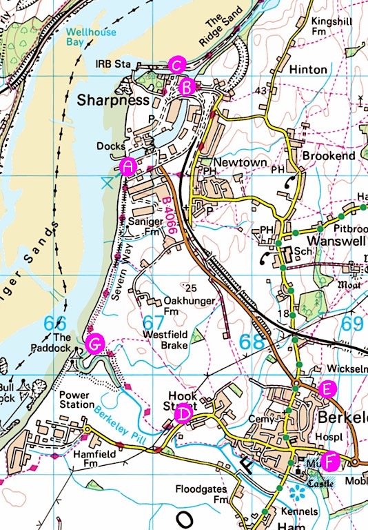
Sharpness Picnic Site by the Severn...
Viewpoint A on the map & shown in the top photo.
Sharpness Picnic Site offers great views of the Severn. It is a short walk from Newtown and Sharpness – and walkable from Berkeley – but it does have a small car park. There are many benches but no loos. Here you can easily watch ships entering and leaving dock – but that happens only around high tide.
If you follow the fence south past the front of the terrace of houses, you will see a stile which takes you onto the salt marsh. The Severn Way then follows the grassy embankment to the mouth of Berkeley Pill – which is G on the map.
The sewage works are just past the big modern warehouses. You will cross over stream/water outlets before reaching the larger Pill.
The High Bridge at Sharpness...
Viewpoint B on the map.
To the north, the High Bridge offers brilliant views of the entrance to Sharpness Docks from the Gloucester & Sharpness Canal. The extremely tidal upper Severn Estuary can be seen beyond the canal.
To the south, the High Bridge offers a bird’s eye view of the low bridge and the main basin of the New Dock.
It is a short walk to the High Bridge from Sharpness, Newtown or the picnic site. It is possible to park on the gravelly/grassy area by the turning up to the Dockers’ Club – mind the massive holes and puddles!

Walk over the bridge to enjoy the 360 degrees view.
The High Bridge – or high level bridge – is still open to cars but barely used by traffic. However, Stroud DC’s local plan proposes that all traffic to the north west of the dock – including 300 new homes, a hotel and a holiday camp – will use this high level bridge and the residential Oldminster Road as the sole access.
Crazy plan?
The low level swing bridge and dock road will be used to access the north east of the docks only.

Most boats travelling between Gloucester and the Severn pass under this bridge – an exception being when the tall ships come through. The High Bridge is actually a swing bridge too, though these days it needs to swing open for the taller ships.

To the east of the bridge, the road continues over a second bridge which is currently blocked to traffic but open to walkers and crosses above very low lying land. An old railway bridge can be see running parallel and has become an unusual haven for wild flowers.

Coastal Flooding v Fluvial Flooding...
There are two causes of flooding that Berkeley and its environs are subject to, tidal or coastal flooding, and flooding due to rainfall. Rainfall can result in river flooding (called fluvial flooding), standing water (eg on some local fields prone to water logging), excess water runoff, and overflowing or blocked drains.
The banks of the River Severn will be set to flood more and more often and at much higher levels than ever before given rising sea levels caused by global warming. Storm surges, which are high tides caused by violent weather systems out at sea, will become more frequent and will in turn raise the levels of the river, causing it to burst its banks.
Dealing with coastal flooding, especially when there are inadequate sea defences (as there are here) is incredibly difficult. Sea water cannot easily drain away past defences that were meant to keep it out and the damage caused to fields by sea water effectively turns it into salt marsh land.
Building higher sea defences only pushes these huge volumes of water up the river causing more severe issues for the towns and villages north up to the city of Gloucester so is not a easy or cheap solution.
Sewage works that sit along the riverbank will also be affected. (No need to go into detail here, I’m sure you can imagine!)
Sharpness Marina & Old Dock on the Gloucester to Sharpness Canal Towpath
Viewpoint C on the map.
Sharpness Marina and the Old Dock offer incredible views of the Severn looking over the wall and upstream They also come with easy walking along the Gloucester & Sharpness Canal’s towpath.
This was the original shipping route to the Severn but is now a dead end. The old lock can still be seen though.
Sharpness Marina and the Old Dock can be reached by the towpath from Purton, or by going down the track from the turnoff to the Dockers’ Club (where parking is possible on the rough gravelly/grassy area).

Much of the UK coastline has been developed with what is called ‘coastal infrastructure’ which can be anything manmade including walls, embankments, power stations, buildings, harbours, marinas, roads, railways, tourist infrastructures, and more.
This is especially true of Severn Estuary and particularly its coastlines in Somerset and South Wales. That is problematic as it means not only is there a lot to ‘defend’ from the sea, but there is also a shortage of places which could be allowed to act as flood plains. So worsening storm surges will continue to be pushed upstream to Berkeley, Sharpness and beyond to Gloucester. In fact, studies have shown that due to the funnel shape of the estuary, a storm or tidal surge increases exponentially as it travels upstream.

This area of land seen over the wall from the towpath is a salt marsh, meaning that it lies between the lowest low tide and the highest high tide marks. So the lower part of a salt marsh is covered by tide water almost every day whilst the highest part may be covered only very occasionally.
This particular salt marsh area is important as a high tide roosting area for birds year round, and as a habitat for ground nesting birds that breed here in the spring/summer. The migratory birds feed on the food rich mud flats and sands but need somewhere safe and undisturbed to roost when the tide is up.
But rising sea levels and man made infrastructure cause ‘coastal squeeze’ meaning the salt marshes have nowhere to exist and the birds have nowhere to survive.
Salt marshes are also important habitats for other wildlife and are excellent carbon sinks – better than forests! So they should have a role in the UK for soaking up CO2.
Even more development along the estuary will give less flexibility for expanding salt marshes and creating flood management zones. It also creates pollution which threatens the birds and the all important food chain of the mud flats.
Sarah's Field & Lynch Road, Berkeley...
Viewpoint D on the map.
Sarah’s Field was given to Berkeley and is named after the lady who owned it and once kept her horses there. It is now a special wildlife place maintained by local volunteers. Dogs must be kept on a lead. There are lots of grassy paths to enjoy.
Sarah’s Field is a very short walk from Berkeley town centre. It can be found on Lynch Road, on the right going out of Berkeley, past the Boar’s Head but before Hook Street.
Walk around the soft, grassy paths of Sarah’s field and sit down and enjoy the two ponds and all that nature brings.
Then go further down Lynch Road to look up the river and see its common reed bed.

Although the two wildlife ponds here are man made, this is a naturally damp landscape. A variety of apple trees have been planted here.
Please keep a very close watch on children near water and do not let dogs go in the ponds which are for wildlife.

Along the border of the field runs a small river which in summer is full of very tall common reed.
A lush green line of common reed can be seen growing front of the row of conifers in the above photo. It really is a vivid green at this time of year!

Although the river looks small it can be very deep and dangerous, Please keep an eye on children and keep to the paths.

This is the river as seen from the pavement of Lynch Road. The little vale running through here is already a boggy area and Lynch Road does get flooded in this area. This vale is a key wildlife corridor and although the very lowest part will not be built upon, Stroud DC’s local plan does propose that houses are built on the land directly adjacent to it!
Berkeley's Flood Plain & Canonbury Rise effect...
Viewpoints E & F on the map.
Both viewpoints E and F revolve around the brook which struggles to drain the land to the north east and east of Berkeley.
Viewpoint E is looking over the floodplain and towards the Cotswold Edge. It can be seen from either a pavement near the entrance to Canonbury Park, or from the public right of way footpath which runs across the fields via a stile almost opposite that entrance.
Viewpoint F is looking across the field which is below the castle’s main entrance. It can be seen from the pavement just before the castle entrance on the way into Berkeley

Viewpoint E: These fields to the east and north east of Berkeley have always been prone to flooding. However, many locals have been commenting that the flooding has become much worse since the new Canonbury Rise development. In fact, last autumn/winter/spring the flood water was there for months on end (whilst on the south side of Berkeley the flooding was less than usual).

A pair of bright salmon pink Flamingoes have recently taken up residence in what is now known as the Berkeley Lagoon. They have apparently been spotted wading and feeding – well, maybe just standing – in the flood/scrape area which is just below the castle entrance.
A bit more on the Local River Flooding...
River flooding is something we see around Berkeley a lot. I have had to divert two of my walks around completely impassable footpaths. One walk turned into two when it simply wasn’t possible to get from Berkeley to Sharpness down any byway only a few weeks ago in late May!
The increases in rainfall we’ll see as a result of climate changes will have a knock on effect of flooding all the tributaries into the Severn around here, and will also lead to standing water in fields and all around.
This will affect the infrastructure, rendering roads either impassable or decimated by the water, as we are seeing constantly around here with the ongoing issues of potholes.
The two strategically placed flamingos in Berkeley Lagoon in the field below the castle recently was a funny way of drawing our attention to a very serious problem!
Given the continuing worsening of flooding due to the climate crisis we are currently living through, it seems absolutely astonishing to me that a huge new town would be planned on a flood plain abutting the banks of an estuary.
Not only does this proposed development decimate some of the only natural defences we have against global warming such as bulldozing ancient hedgerows and trees that absorb a huge volume of carbon in our atmosphere but it also exacerbates the issue by causing more water runoff, causing flooding in more surrounding areas.
The continual flooding of the field below the Canonbury Rise development is proof enough of this issue (as is the apparent subsidence and the estate isn’t even finished yet!).
Where the Little Avon River & Berkeley Pill meet the Severn...
Viewpoint G on the map
The Little Avon River and the Pill merge on the western side of Berkeley and from there on the river is called Berkeley Pill.
The mouth of Berkeley Pill is in what can pleasantly feel like a remote and wild place and this area is used by birds of the Severn for safe and undisturbed high tide roosts.
This area can be reached by following the Severn Way from either Berkeley or Sharpness Picnic Site (A on the map).

It can be surprising to discover how high above Berkeley Pill the Severn can be at high tide. A sluice gate stops the Severn running up the Pill. When the river is full and ‘in flood’ and the Severn is high, the only option for the Pill and the Little Avon River is to flood the surrounding area and further upstream around Berkeley.

Despite the power station on the other side, this area can feel remote and wild and is currently little visited by humans – one of the reasons why it is used as a high roosting area by the birds.

The Severn inlet around the mouth of Berkeley Pill can be surprisingly wide at very high tides. A large amount of drift gets washed up on those tides – mainly old common reed stalks but also some tree branches, curiously a surprising number of chairs, and sadly an awful lot of plastic and glass bottles.
Before we finish...
There are more articles on flooding on this website and I will be talking about it in the meetings I am organising for next week too. We at Berkeley Byways are not professional experts, we have simply done our research and are appalled that such a huge and devastating development could be given the green light here.
I hope you enjoy the viewpoints this week and the visits to places you might not have been for a while. Enjoy everyone! More posts on the upcoming meetings will be coming soon.
Other flooding articles and dramatic photos and maps are on this website at: