What land around Berkeley & Sharpness will be under water by 2050?
The photo above was taken in March 2020 looking from Sharpness Dock towards Berkeley Pill.
The tide above was not an especially high tide but a regular spring one. For the above photo, the weather had been fine and calm out in the Atlantic. So there was no storm surge on this occasion – when the weather far out at sea is bad, it brings a ‘storm surge’ which causes the tide to be significantly higher.
With sea levels rising – and this is beyond doubt – much of the land around Berkeley and Sharpness is expected to be permanently lost to the rising high tide mark. In the past, Berkeley was known as ‘The Town in the Marshes’ for a good reason!
The maps below shows what land in the Berkeley & Sharpness area is expected to be under water by 2050. This is from Climate Central – an independent organisation of leading scientists and journalists who research climate change and its impact on the public – at https://coastal.climatecentral.org/ The reality is that it will get far worse by 2100, and even worse after that.
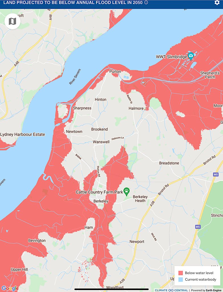
Land around Berkeley & Sharpness expected to be flooded by tides each year by 2050
As can be see from the map above, the much touted employment hub around the specialist colleges and the old Berkeley nuclear power station will be flooded by high tides annually, as will the employment areas around Sharpness Docks.
The main access road into Berkeley and much of the Berkeley bypass road to Sharpness from the A38 will also be flooded by high tides annually. So will the A38 north towards the M5 junction.
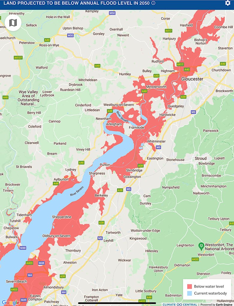
A wider view of land around Stroud District expected to be flooded by tides each year by 2050
Has there been coastal flooding here?
In 2013 there was extensive coastal flooding to the south of Berkeley which took months to drain. Settlements such as Elmore further upstream already suffer high tide flooding more often with frequent flood warnings. The high spring tides already regularly deposit the line of driftwood over the top of the sea defences along the estuary here and for miles along – including onto Sharpness picnic site.
Could the sea defences not just be raised?
If the sea defences here are raised, more sea water will be pushed upstream causing flooding towards Gloucester with its low lying areas.
There is also the serious environmental issue of ‘coastal squeeze’. The salt marshes which are essential for the birds and biodiversity – and are important carbon sinks – will simply disappear.
The pressure on coastal infrastructure is going to be very severe along many parts of the UK’s coastline!
There will not be nearly enough money to meet the enormous cost of reinforcing and raising sea defences – hence why the Environment Agency is changing the status of many stretches of coastline – and that includes estuaries – from defend to ‘retreat’ status.
So it makes no sense to add to this pressure by building a new settlement here!
Is coastal flooding worse than river flooding?
When coastal flooding happens, it is more damaging and longer lasting than river flooding – bad though that is for those affected.
The incoming tides are extremely powerful and the quantity of water is vast and the flood happens very suddenly and quickly. Afterwards, the water cannot quickly drain back out to sea – ironically, the water is trapped on land by the sea defences built to stop water passing through!!
The saltiness of the water causes long lasting damage to farmland. Once the water has finally gone – many months later – the land is still not recovered.
This is what happened in the area south of Berkeley a few years ago. Without doubt, it will happen again.
When the effect of rising sea levels is taken into account, this situation will only get much worse.